Utah
Thanks to our reputation for thorough unground utility locating services, we get called to work on some pretty serious jobs. One such job was for a prestigious government facility in Utah. We aren’t at liberty to say the name of the agency or give details about the facility, but it would be safe to say that the stakes were high on this particular project. Our team came prepared and with the mindset that success was the only option.
As we often do, we employed a multi-tool approach to this utility locating assignment, which paid off big time when we made a surprising discovery.
Underground Utility Locating for a High-Profile Government Client
Our government client had plans to raze their entire facility and build a completely new one. Along with the building plans came a lot of earthwork, and they wanted to ensure that they didn’t hit any pipes or other underground items on their two-acre site in the process. They asked the Enhanced Scanning team to provide underground utility locating services on the entire two-acre property.
Because we were working with a well-known facility, thoroughness was key. If our utility locators missed anything and the construction crew later hit something they weren’t supposed to and had to stop working, it would certainly make the evening news. Our client obviously wanted to avoid any unfavorable press, so this definitely upped the pressure on our team.
Using Multiple Tools for Underground Utility Locating
For this particular job, we decided to use three different tools. Each tool comes with its own pros and cons, but when used in tandem, they give us very comprehensive results. We utilized the following tools:
- Single-channel GPR antenna
- EM pipe locating wand
- Soil conductivity meter: Profiler by GSSI
We started with the electromagnetic (EM) locator and the ground penetrating radar (GPR) antenna. We scanned the two-acre lot several times, moving back and forth in different directions to make sure the entire site was covered. Then, we went back over everything in large swaths with our soil conductivity meter.
Soil conductivity meters are amazing tools and provide different data than GPR scanning can on its own. They make it possible for us to locate any conductive changes in the soil. This means they can pick up on details like hydrocarbon plumes, contaminants from landfills, leaks from underground storage tanks, and more.
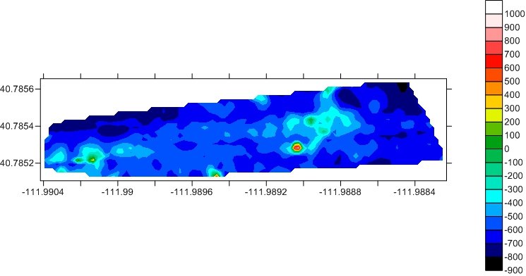
Soil conductivity meters spit out data by way of a heatmap consisting of green, blue, orange, red, and yellow concentric circles. These circles indicate the presence of hot spots, which are underground areas with higher levels of conductivity.
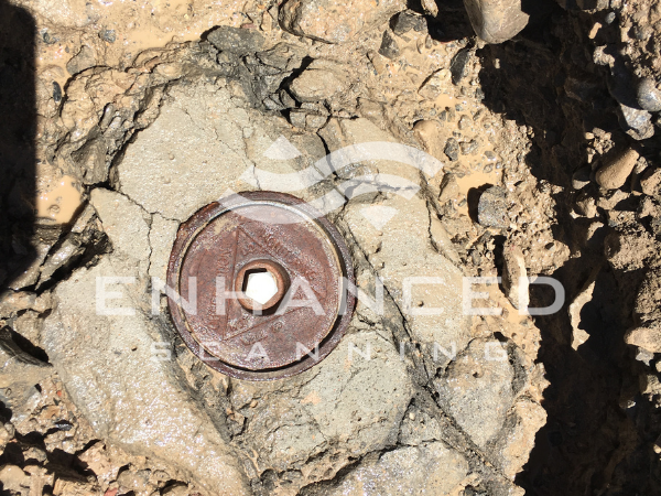
A Tiny Red Mystery Spot Captured by Our Soil Conductivity Meter
After we finished scanning the property, we went back to the office to process the data found by the soil conductivity meter. Everything aligned with what we had already found using our GPR antenna and EM pipe locating wand, with one exception: a tiny red spot in the middle of the heatmap.
We grabbed our handheld magnetometer, referenced the GPS, and went back out to the property to take a closer look at the mysterious spot. When we arrived at the location of the red spot, we used the magnetometer to isolate its exact location. We told our client, “Our soil conductivity meter and magnetometer are both telling us there’s something right here, but we don’t know what it is.”
When you do underground scanning for a living, you don’t often come across things you haven’t seen before. In fact, it’s extremely rare for our team to encounter a situation that we can’t explain—and yet, we had no idea how to explain the red dot. So, we marked the spot with a flag and spray paint so we could easily return to the location.
It turned out that the red spot indicated the presence of a monitoring well that absolutely no one knew about, located roughly ten inches below the ground’s surface. A monitoring well is a pipe that goes straight into the ground and is used to take soil samples in areas where soil contamination is a concern. You typically find them around gas stations, mechanic shops, and other places where contaminants can easily enter the groundwater.
It appeared that this particular monitoring well had been undisturbed for decades—apparently forgotten about!
Using the Right Tools for the Job to Ensure Thorough Results
Had we just used an EM wand and a GPR scanner, we almost certainly wouldn’t have found the tiny, six-inch spot on this two-acre site. While we didn’t exactly find buried treasure, our client was very grateful for our find, nonetheless. If the monitoring well had been hit during the construction process, the outcome would have certainly been that work would have been forced to stop. However, since we used a combination of tools, we helped keep our client’s project on schedule and on budget. This counts as a “win” in our book!
Not only did we have all the right tools for the job, but we also knew exactly how and when to use them to make this job a success. At the end of the day, our approach was extremely thorough and yielded the results our clients needed.
At Enhanced Scanning, our creative and resourceful team is ready to tackle all of your underground scanning needs. If you’re seeking an underground scanning service provider that is meticulous, detail oriented, and experienced, contact us today.