Kellogg, Idaho
This job in Kellogg, Idaho put our GPR scanning skills to the test on a high-stakes project in a hazardous environment. The Enhanced Scanning team was tasked with providing underground utility locating services for a superfund site. Working on a superfund site is dangerous work that requires precision and focus. Fortunately, our team has both in abundance!
What Is a Superfund Site?
A superfund site is a location that has been severely contaminated to the point where it is dangerous to the environment and the health of those in the surrounding communities. The Environmental Protection Agency (EPA) is responsible for identifying superfund sites.
The Comprehensive Environmental Response, Compensations and Liability Act (CERCLA), which is better known as Superfund, grants the EPA the right to direct the cleanup of the sites designated as contaminated and force the parties responsible for the contamination (typically processing plants, manufacturing facilities, landfills, and mining companies) to perform the cleanup or reimburse the government for doing so.
The Idaho Superfund Site and the Need for a Utility Locating Service
In 1983, the EPA designated a 21-square-mile area of Silver Valley in Northern Idaho as a superfund site. While locals call it “The Box,” the actual name for the area is the Bunker Hill Mining and Metallurgical Complex Superfund site. In 2002, the site was expanded to include the 1500-square-mile Coeur d’Alene Basin, making it one of the largest, most polluted areas of the country.
Why is this area so polluted? Well, mining has been underway there since the 1800s, and since that time, heavy metals in the extracted tailings have been released into the open air. In Kellogg, Idaho, the levels of heavy metals are extremely high, leading to medical complications for many people in the area.
At one point, the Coeur d’Alene River turned milky white due to the heavy metals leaching from the tailings into the water. One of the heavy metal piles is around 300 yards on one side and about 60 feet tall and sits right next to the river.
The EPA’s goal for this project was to stop the runoff water from this tailings pile from ending up in the river. To do this, they planned to build a huge underwater wall to surround the tailings pile. By our estimate, this wall would be about 80 feet underground, 60 feet wide, and three-quarters of a mile long.
Before they could begin building the wall, the EPA needed any underground utilities to be located and clearly marked so that the wall could be built safely. Hitting a buried utility line or other target at the superfund site during construction could be disastrous to both the construction crew and the surrounding community.
GPR Scanning in Hazardous Conditions
Anytime the ground contains toxic contaminants, special care is required in construction. You can’t just blindly dig into the soil and hope you don’t hit anything. Not only would hitting utility lines or other buried items cause delays and increased project costs, but you also run the risk of legal complications due to the stringent soil disturbance regulations in place for toxic sites.
Thorough GPR scanning needed to be done prior to the start of the Idaho superfund site’s underground wall construction. The Enhanced Scanning team was brought in to locate any electrical lines, gas lines, and other buried targets. We were also informed there was a 20-inch steel water line that we needed to locate. This water line had been installed to pump water out of the mine shafts and down to the water treatment facility. It was imperative that the construction crew knew exactly where it was located and not hit it.
Using several different tools from our private utility locating toolbox, including an EM pipe locating wand and a GPR antenna, we devoted multiple days to meticulously scanning the site. Due to the hazardous nature of the site, we needed to tightly control the soil and water movement, while performing as much non-destructive testing as possible. We also wanted to help the construction crew avoid any unnecessary excavation or exploratory hydroexcavation.
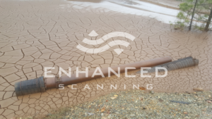
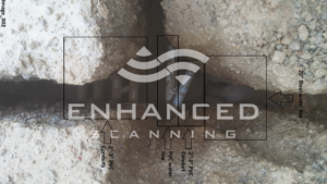
In the end, we were able to locate and mark quite a few utilities, including the 20-inch pipe. Some of the buried infrastructure we found was more than 100 years old!
When conducting GPR scanning in environmentally hazardous locations like superfund sites, or in cases when hitting a target could cause a dangerous situation, thoroughness is not only important to create a safe digging situation—it’s essential!
At Enhanced Scanning, we take great care to be as thorough as possible for every project—even the ones that aren’t EPA regulated. If you need underground utility locating services on your site, contact us today.